Canada Water Masterplan
View all projectsGreen and blue
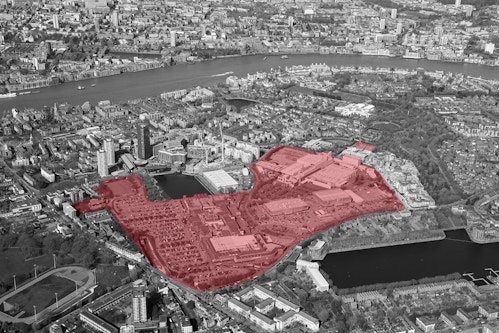
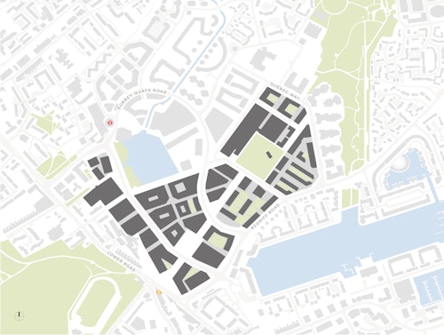
This masterplan is guiding the development of a new urban centre at the heart of south-east London's Rotherhithe peninsula, historically a network of working docks and canals connected to the River Thames - and more recently the home of a 1980s low density shopping centre. Sitting between two underground stations, with access to the water at both Canada Water and Greenland Docks, it offers the opportunity to create a characterful, well-connected London neighbourhood.
Context
On a map, Canada Water's proximity to Canary Wharf and central London is striking, yet the area today feels geographically disconnected and strategically overlooked. The peninsula is however far from being a blank canvas. The physical legacy of the docks has been overlaid with a generous network of green spaces. Large, low-rise retail units, a leisure centre and extensive surface car parking characterise the area whilst an established local community occupies the immediate surroundings. The challenge here is to recognise and reconcile the strengths of the existing with the evident need for an upgraded infrastructure, new homes and opportunities. In addition, the area has been earmarked in local and regional planning policy for regeneration, targeted by the Mayor of London as an area ripe to deliver much-needed new housing.
Encompassing land use, urban design, landscape and public realm, routes and spaces, built form and infrastructure, the illustrative masterplan has grown and developed over a period of years. Our client, British Land, first began exploring options for Canada Water's future in 2013 when both the site and attendant aspirations were smaller. Subsequent changes in local and regional planning policy significantly raised the area's status with a progressively expanding site boundary giving us repeated opportunities to rethink and refine the design through a number of iterations.
1/4
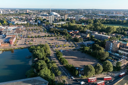
Surrey Quays Shopping Centre with extensive surface car parking
2/4
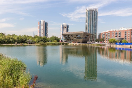
Canada Water Dock looking north towards Canada Water Library
3/4
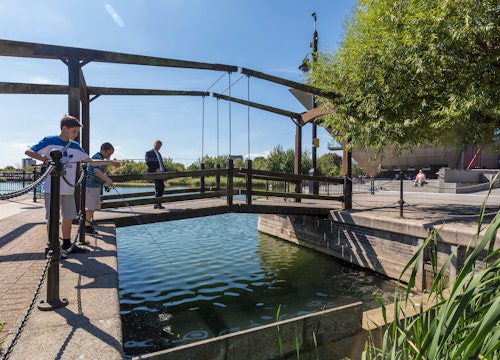
The Albion Channel links to Canada Water Dock
4/4
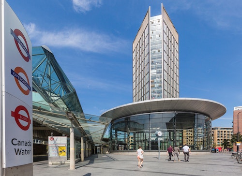
Canada Water underground station
Challenge
As a large site with multiple parties interested in its future, consultation has been integral to building consensus. The process gave us in-depth understanding of the site history, local area and community, and local views and feelings about what a new town centre should be. Six sets of public exhibitions were accompanied by workshops, topic focus sessions and regular newsletters between stages of the masterplan evolution. During each, the emerging masterplan has been taken "on tour" to local resident associations and community groups. Public interest and awareness of the proposals has grown over time, and since 2016 around 1,500 visitors have attended each major public exhibition. To date, consultation has resulted in around 12,000 comments from over 5,000 individuals; input from all of these stakeholders has helped to shape the masterplan.
Southwark Park
Canada Water Dock
Russia Dock Woodland
Greenland Dock
Concept
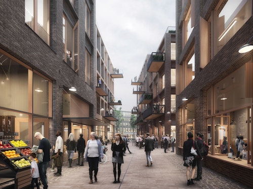
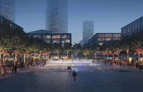
Our proposals replace the 1980s Surrey Quays Shopping Centre with a legible network of streets, lanes and locally distinct public squares. This urban fabric will underpin a richness of uses, from offices, shops and cafes to leisure, community and public places as well as new homes for a range of ages, incomes and life stages. A new 'High Street' along Deal Porter's Way will link the two tube stations, and a new town square will provide a focus for community and social gathering. Just as important are the links into the surrounding green spaces, out to the former dock waterways and woods. There will be new connections to Southwark Park from the west and Russia Dock Woodland in the east, and beyond to the River, through a series of new open spaces, cycle paths and walkable routes, and community gardens and play spaces will contribute to wellbeing of both residents and visitors. The dockside character and riverside setting is celebrated - water is a key amenity. Biodiversity corridors are located to help species to flourish and allow for travel between parks in the wider area. As well as planning for new buildings, key existing buildings (the former printworks, dock offices) are being retained whilst the prioritisation of others will set the tone and design quality standards for the development as well as ensuring that the greater masterplan gains traction.
1/5
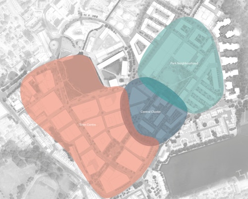
The masterplan is composed of three character areas: the Town Centre, the Central Cluster and the Park Neighbourhood
2/5
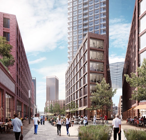
The Cuts: an intricate network of narrow lanes located between Canada Water and Greenland Dock
3/5
The Town Square: a place at the heart of the Town Centre for the local and wider communities to gather
4/5
Park Walk: a quieter, greener route through the central cluster
5/5
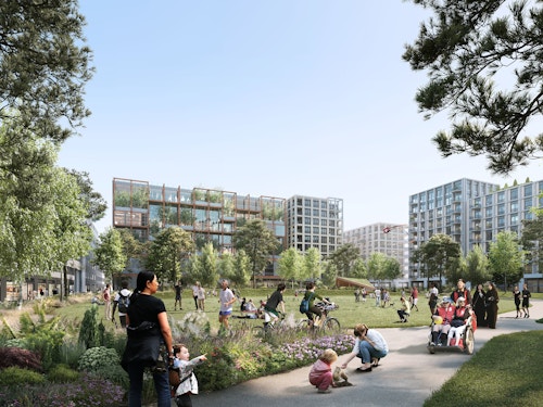
The Park is the centrepiece of the Park Neighbourhood, providing three-acres of open space
Process: Next steps and new buildings
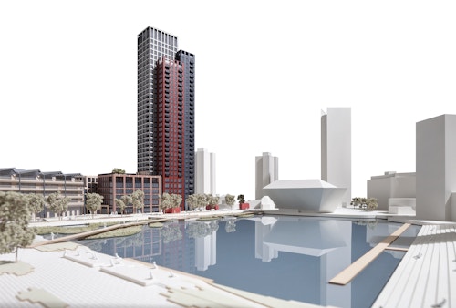
Our masterplan provides a structured concept and framework for development. In order to strike a balance between creating clear principles and objectives to support the creation of a place, and being flexible enough to accommodate change in the longer-term, an outline planning application was submitted that establishes the parameters for development alongside a detailed application for four sites. Two of these, Plots A1 and A2, are buildings we are also designing:
Adjacent to Canada Water station, the first of these Plot A1 is a hybrid building with shops at ground floor, flexible workspace across a 5-storey podium and 35-storeys of housing above. The different uses are expressed as individual volumes; a family of buildings grouped together. The 5-storey podium volume is further broken down, appearing as three distinct complementary buildings that align in height with their neighbours, while the residential tower that rises above them employs a similar tactic, using a wider range of materials and colour to suggest three tall elements of differing heights.
The second building Dock Shed is also hybrid in nature, combining 21,200 sqm of workspace with a leisure centre and swimming pool in a building whose form references the industrial warehouse heritage of the docks. The leisure centre occupies the ground floor and basements while flexible workspace is spread across five upper storeys. Each use has its own dedicated entrance, the leisure centre facing onto a community square that is developing around the Dock Office buildings, with all activities - gym, swimming pool and indoor courts - on show, via a large, open daylit stairwell.
Information table
- City
- London SE16
- Use
- Mixed
- Client
- British Land
- Status
- Current
- Size
- Masterplan 21 ha
- Units
- 3,500
- Collaborators
Landscape: Townshend Landscape Architects
Sustainability, transport and energy: Arup
Environment and infrastructure: Waterman Infrastructure and Environment
Access: David Bonnett Associates
Acoustics: Sandy Brown
Daylight and sunglight: Gordon Ingram Associates
Fire: Olsson Fire and Risk
Legal: Herbert Smith Freehills
Lighting: Speirs and Major
Socio-economics: Quod
Cost: AECOM
Security: QCIC
Townscape: Tavernor Consultancy
Wind: RWDI
Sites of Importance for Nature Conservation: London Wildlife Trust