London's Local Character and Density
View all projectsLondon's multiple characters
This study provides a contextually-rich reframing of how London could plan for intensification. It reveals a fine grain picture of urban character across the capital, identifying fifteen character types reflecting London's unique evolution over 2,000 years. It asserts that each character type can contribute to growth and that this diversity of character unlocks greater capacity for future development. A key output was they creation of a comprehensive character map of London, which has been adopted into the new Draft London Plan.
Context
For the first real time in London's history, we are seeing a major programme of densification across the city. The impact this development is having on the identity of London is profound. In central London, the setting of highly valued heritage assets is changing significantly. Outside the city's Central Activities Zone (CAZ), large Opportunity Areas (that is, predefined areas targeted for intensification in the London Plan) are introducing new typologies and urban characters adjacent to long-established neighbourhoods. In some instances, the planned change in character looks to be abrupt and is taking relatively little reference from existing adjacent areas.
Seeking to positively contribute to the debate over how London is developing, Historic England commissioned us to undertake a comprehensive mapping and study of London's historic character. This work sought to explore the potential conflicts emerging at all scales of planning and development, with a view to establishing a common assessment framework to steer more contextually-informed growth across London.
Challenge
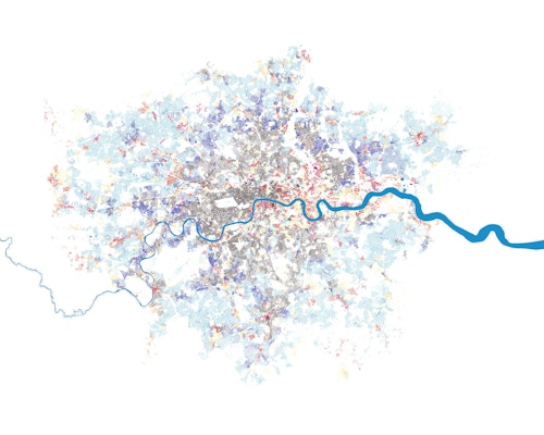
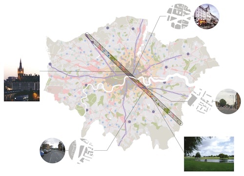
Understanding the underlying character of different parts of London was fundamental to the study. London is a big place and an old city. It is in fact, multiple settlements, so the identification of its character was a complex undertaking of mapping the city based on a series of detailed information layers, including historic maps, historic and current land use, street structure, transport infrastructure, existing densities and heritage designations. This involved a multilayering of spatial data using Geographical Information Systems (GIS) to visualise different characteristics across London. A transect we took from one end of the GLA boundary to the other - uncovered a rich tapestry of previously underappreciated typologies and different densities, which have developed relatively independently from their location within London's central, urban and suburban zones.
Concept
The historic evolution of London was used as the primary factor in the definition of character areas. These start with the original outline of Londinium, the Roman city, and then move outwards with each historic period of growth. Information about land use, density, infrastructure and street morphology was then used to establish a more nuanced interpretation of character.
A sequential process of cartographical analysis started with mapping the development and sprawl of London, mapping the urban footprint over time. Historic map sources such as the Hoefenagel map (1572), Davies map (1847) and Stanford map (1884) helped to form a base map. A second layer was then added on to this which adds greater detail to represent unique characteristics such as green spaces and the Green Belt, the legacy of the industrial revolution, infrastructure, waterways and the original high roads into and out of the city of London. Recognising that the London as we know and define it today is actually much larger than the original City, a third layer grafted on the towns, villages and settlements that grew up in the shadow of London only to become integrated into London itself over time.
The following character areas were identified: Londinium - the original Roman city later built over in the Medieval era; Georgian planning and growth; Victorian entrepreneurship and suburbs; the historic villages; former medieval market towns; suburban town centres that emerged with Victorian railway development; 20th century centres; 20th century suburbs; London's historic high roads; remnants of 19th century industry; waterways; the River Thames; the Green Belt; green open spaces; and Heathrow Airport. The footprints of each of these were overlaid onto a single map which provides a comprehensive and detailed picture of London's character.
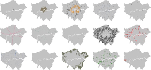
Londinium
Georgian
Victorian
Historic Villages
Medieval Market Towns
High Roads
Railway Town Centres
20th Century Centres
20th Century Suburbs
19th Century Industry
Waterways
River Thames
Green Belt
Green Spaces
Heathrow
Process
Our study revealed a range of issues impacting London's historic built environment. Firstly, the importance of character. Understanding London's unique identities is inseparable from studying the way it has grown. London's heritage is best conceived as a palimpsest, with layers of history reading through to the present day. These can be traced in the public realm and plot divisions, determining the grain and scale of historic places.
London's growth has largely been organic, polycentric, speculative and unplanned, responding to a multitude of circumstances. From the Romans onwards, these circumstances have been administrative, civic, economic and defensive. London has also been conditioned by regulations, often motivated by public safety but also serving to protect the amenity of private landowners. It is there prescriptive controls that have shaped the nature of the capital more than formal plans.
Another finding is that the management of uplift in industrial areas will be a critical factor in London's future development. Many of the growth areas, and in particular London's Opportunity Areas, are identified on 19th century industrial land. The benefit of this character type is that as long as the historic grain and street morphology provide the bedrock for future development there is a whole range of typologies and densities that could be accommodated.
The study also reveals a relationship between transport and density. The thrust of policy in London over the last decade has been to push the highest densities to those locations with the best public transport accessibility. In many cases, this coincides with historic town centres. There is clear logic behind this, however, there have been many examples where the format of development has delivered inappropriate intensification. There is a need for a more contextual approach.
This study has established a broad characterisation of Greater London as a proactive contribution to the debate around the residential density matrix and its application alongside a wider consideration of land uses. Using Geographical Information System software, it has created one of the most comprehensive mappings of London's local character to date. Transects through it reveal a highly textured and complex urban picture.
Impact
The report recommends that a character-based approach should be incorporated into strategic policymaking with regard to local plan-making and the management of land use change and development proposals. This report illustrates that every character type in London can accommodate growth and that heritage assets can contribute positively to this. The mapping process could be a powerful tool for developing more contextually-aware urban design in the future.
The study's London-wide character map was adopted into the Draft London Plan first published by the Mayor of London in 2017. That same year, the study was awarded a RIBA President's Award for Research. It is also the genesis of Complex City, a forthcoming book to be published by the practice in 2020.
The Square Mile
Ancient High Road
Green Spaces
Historic Town Centre
Victorian Industrial Legacy
a transect through London reveals the diversity of characters
Information table
- City
- London
- Use
- Mixed
- Client
- Historic England
- Status
- Completed
- Awards
RIBA President's Award for research 2017