In Britain, in the last century, most discussions of urban, or suburban, development typically regarded density as a threat. Design proposals which appeared to maximise, in terms of area, the development potential of a site were invariably criticised as being "too dense", a threat to established notions of scale, privacy or character. But as we move further into the twenty-first century and we cope with the consequences of a world in which we are competing for an ever-diminishing supply of space and resources, density, or more accurately, increased density, is becoming acknowledged as an essential prerequisite for sustainability.
Today we need to build more compactly - to live and work more closely together - because it is only in this way that we can reduce the need for our towns and cities to expand and therefore limit our impact on the surrounding land. Concentrating development allows us to minimise our need for transport and therefore be more effective in our consumption of energy. It also makes it easier to provide the range of resources and facilities needed to support a vital social and cultural life and to ensure their long-term viability.
Of course, high-density living does not come without some potential disadvantages. Lack of privacy, reduced amenity space, close proximity to neighbours, restricted sunlight and daylight, shortage of storage, overshadowing and overlooking are all problems that may result from high-density development, while questions will always be raised as to its appropriateness as a setting in which to bring up children. Therefore while current planning policy in London, for example, does now encourage density – particularly in relation to major transport nodes – such proposals are still widely viewed with suspicion.
Nevertheless, as the concern of policy makers changes from whether projects are too dense to whether they are dense enough, so the accuracy of our assessment of density becomes increasingly important. It might even, at some point, be appropriate to be able to reward, or compensate, those living at higher densities – and therefore occupying less land and requiring a smaller share of public services – by for example lowering their level of taxation, just as different categories of vehicles are taxed according to their fuel efficiency.
Calculations of residential density have conventionally related numbers of people, or dwellings, or habitable rooms, to the area of the site. These simple ratios, however, fail to acknowledge many critical aspects of a development. They do not, for example, take into account areas allocated to other uses such as retail, car parking, transport, or workspace. They do not reflect the extent to which areas of the site have been opened up as public realm rather than retained for private, or communal, use. And they ignore the impact of neighbouring land uses – of areas of open space, parks, riverside or sea front. In short, they disregard the qualitative consequences of density, how it actually feels on the ground.
Of these omissions, the latter is perhaps the most difficult to address as opinion will inevitably divide as to the merit, or justification, of taking off-site land uses into account. But a measure of residential density that reflects both the proportion of the site area allocated to the public and the proportion of the development area allocated to other uses might be possible.
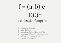
Just as we can measure an individual’s carbon footprint, so it would seem helpful if – as part of the documentation of a development project – we were able to establish what share of the site area is effectively being allocated to each new resident, to define, in other words, what will be the “residential footprint”, measured in metres squared, of each person living within the scheme.
What is considered an appropriate residential footprint will vary according to its location, and in particular in relation to its proximity to other facilities – shops, transport, schools. But in principle the smaller our residential footprint, the less land we occupy and the more sustainable we are.
In order to assess the residential footprint of an individual, we need to relate the area of the site (excluding any land retained for public use), firstly to the proportion of the total development allocated to residential use and secondly to the number of inhabitants expected to occupy it. This can be calculated using the formula shown here.
Applied to a typical three-storey London terraced house occupied by a family of five, with a small front garden and a 10 metre deep rear garden, a calculation of the residential footprint of each occupant is likely to be around 30 square metres.
In contrast, if this formula is applied to the projects illustrated in this book, all of them achieve significantly lower residential footprints ranging from 17.9 square metres per occupant for Wolvercote, to 4.8 square metres for St Andrews Bow, and as low as 1.8 square metres at Aldgate Place.